Project Gaia: AI and Drone-powered Game Census across 100 000 ha of the Timbavati and Sabi Sand Nature Reserve
.jpg)
Project Gaia
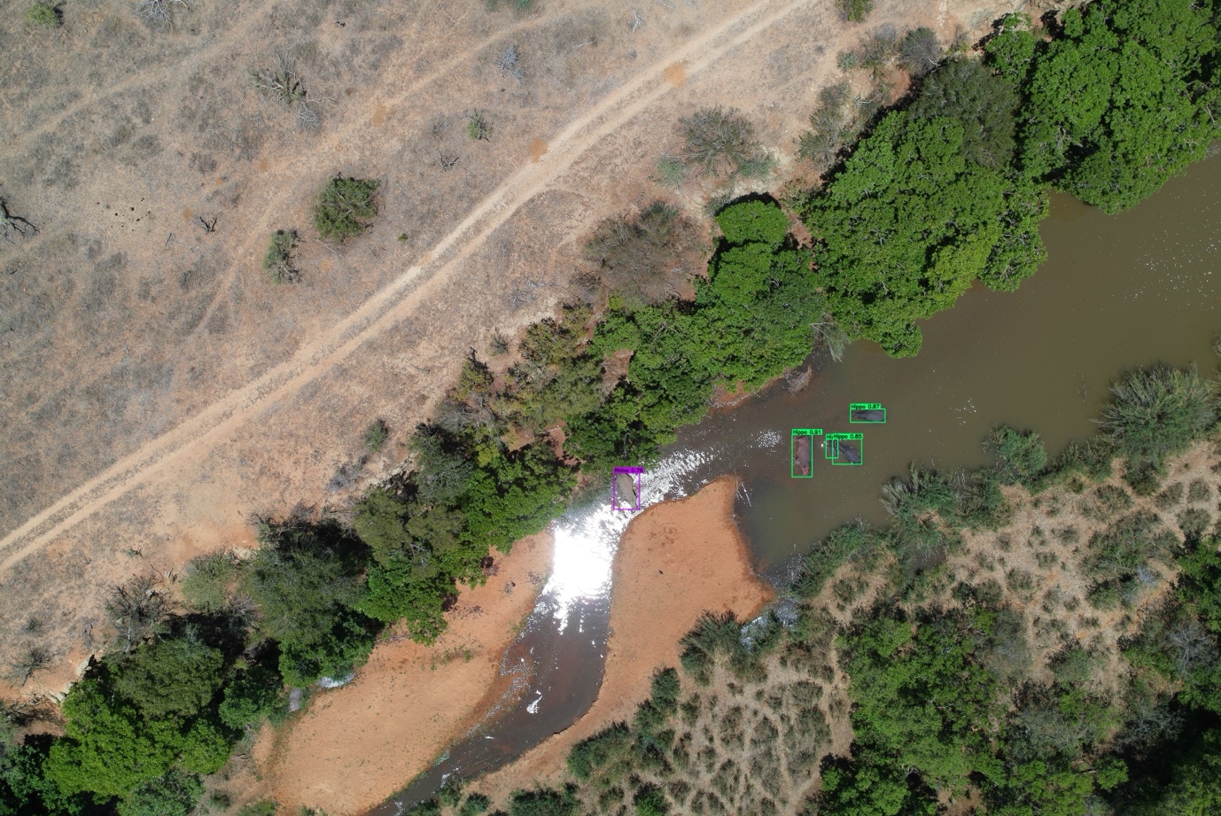
We’re proud to share the successful completion of Project Gaia, an AI- and drone-powered game census covering 100,000 hectares across the iconic Sabi Sand and Timbavati Nature Reserves. This project is the brainchild of Veriphy Technologies, in collaboration with Chisl, the Timbavati Nature Reserve, and the Sabi Sand Nature Reserve. Its aim is to survey large mammal species across extensive open-system conservation areas using drones, machine learning, and artificial intelligence.
The survey simulated an annual aerial game count using the same Total Area Count (TAC) methodology applied in traditional surveys, but with drones capable of capturing five images per second from different angles. This approach reduces costs, improves detection accuracy, and produces more reliable, evidence-based estimates. It also opens the possibility of conducting broader ecological surveys in future, including vegetation and habitat analysis. The Timbavati Nature Reserve contributed 55 percent of the total 100,000-hectare test survey area.
.jpg)
Survey specifics
- Total transect length flown in Timbavati: 11,000 km
- Total number of photographs taken: 1.85 million
- Survey period: 5 consecutive days
- Average coverage: approximately 11,000 hectares per day
Project outcome
Initial results from the AI-trained models are highly encouraging. Findings align closely with traditional survey methods for larger animals, while indicating a higher detection rate for grazers. Future model training will incorporate the Timbavati dataset to further improve accuracy, after which the imagery will be reprocessed to produce the final survey results.
Pros and cons of the survey method
Pros
Cost efficiency
Once fully refined, this technology is expected to be more cost-effective than traditional fixed-wing aircraft or helicopter surveys.
Minimal disturbance to wildlife
Very little disturbance was observed. For example, kudu continued feeding and predators continued grooming while drones operated quietly at approximately 90 metres overhead.
Verification and long-term monitoring
Each observation is supported by a permanent photographic record, enabling verification and creating a valuable dataset for future analysis. This includes tracking ecological changes such as vegetation health, erosion, water bodies, invasive species, roads, and human impact.
High-resolution mapping
The platform provides a detailed, high-definition map of the entire reserve, with up to 15 images from multiple angles available for any location. GPS markers can be added to monitor landscape changes year-on-year.
.jpg)
Cons
Sexual dimorphism not yet fully distinguished
Current AI models cannot reliably differentiate between males and females of species where separate counts are required. Additional model training is needed.
Small antelope species not fully differentiated
Species such as duiker, steenbok, and klipspringer are currently grouped under a general “small antelope” classification. Future training will allow for more precise identification.
What this means for conservation
Project Gaia highlights the growing role of advanced technology in modern conservation management. As protected areas expand and operational costs rise, scalable and data-driven tools are becoming essential for monitoring wildlife accurately and efficiently across large landscapes.
Drone- and AI-enabled surveys provide a repeatable, lower-impact, and evidence-based alternative to traditional methods, while reducing reliance on fossil-fuel-intensive aircraft. At scale, this approach has the potential to transform how reserves conduct game counts, allocate conservation resources, and track ecological change over time.
For the Timbavati Nature Reserve, Project Gaia represents more than a new survey method. It marks a shift toward smarter, more resilient conservation, combining field expertise with advanced technology to protect wilderness more effectively into the future.
.jpg)
.png)


Where to next?
.jpg)


@timbavati_pnr
